Fisheries Data Mapping: Maps for Over-12m Vessels Now Available
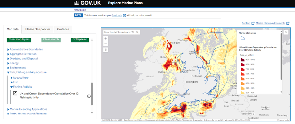
The Marine Management Organisation's (MMO) Marine Planning Team is pleased to share a significant step in its Fisheries Data Mapping project. Following an update in May, the team has now published maps showing the distribution of UK and Crown Dependency over-12m fisheries on the Explore Marine Plans platform. The MMO aims to publish information on other fisheries in due course.
This initial release has already proven useful, for example, by providing information about the location of fisheries for the modelling, planning, and leasing for offshore wind by the Crown Estate.
Important Context and Caveats for the Data
The MMO emphasises that there are several key caveats associated with this mapped data:
- Data Timeliness: The mapped outputs were created with data up to 2021 for UK data and 2020 for non-UK data. Further data for 2022 and 2023 is currently being processed for future analysis.
- National Scale Analysis: The analysis was conducted at a national scale for English, Welsh, and Northern Irish waters. The MMO notes that regional areas of importance with lower fishing activity, which might represent high local social and community value, could be excluded from this national analysis.
- Historical Data: The data shows current and historic fishing effort and makes no predictions about future fishing activity or displacement.
Collaboration and Continued Development
Acknowledging the complexity and diversity of the fisheries sector and its associated data, the MMO believes it is critical to explain and share the outputs of its analyses with the fishing industry. This collaboration helps to ground-truth and triangulate the findings, as was done in 2023.
The team is continuing to review and develop the approach to improve and update the outputs from the initial analysis, incorporating feedback received during the 2023 engagement. They hope to provide more updates and discuss further with fishing interests in the near future.
The MMO encourages everyone, particularly industry stakeholders, to review the information presented and provide comments at the next engagement point, which will be promoted through their usual channels. Alternatively, stakeholders can contact the team through the marine planning mailbox, planning@marinemanagement.org.uk, or by using the “data feedback” link on Explore Marine Plans.
Addressing Data Gaps
Alongside the mapping of over-12m vessels, the MMO continues to gather other information and undertake relevant research. This includes publishing the report on the spatial distribution of under-12m fishing activity and its sensitivity to offshore wind in the East marine plan areas. This work begins to address some shortcomings with other mapped outputs by looking at under-12m fisheries in more detail. These outputs will also be published on Explore Marine Plans in due course.
Finally, the MMO looks forward to continuing to work with partners, including different members of the Defra group with specific responsibilities and expertise in fisheries, such as Cefas, JNCC, Natural England, and Seafish. Together, the goal is to provide the best information and insight to inform not only fisheries management but also wider initiatives such as marine spatial planning.
No comments:
Post a Comment
Please note - inappropriate comments will not be published.